Live updates: Tens of thousands still without power in Western Washington with more wind ahead

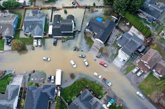
- Flood waters are receding Thursday, but a flood watch remains in effect for several Western Washington counties. Meanwhile, farmers continue to assess damages and the cleanup that lies ahead.
- The number of Western Washingtonians still without power sits at roughly 40,000 as of early Thursday afternoon, a day after high winds and fallen trees caused outages for hundreds of thousands.
- But more outages could be on the way, as the National Weather Service has issued wind advisories in many counties throughout the region.
- Flood warnings remain in place for some rivers as of Thursday morning, including the Cedar River in Renton, the Green River near Auburn, the White River in parts of Pierce and King counties, the Snohomish River at Snohomish, and the Skagit River near Mount Vernon.
- Gov. Ferguson on Tuesday pledged $3.5 million from the state budget to assist people impacted by recent historic flooding.
- One person drowned Tuesday morning after driving on a flooded roadway in Snohomish. It marks the first flood-related death since a series of atmospheric rivers moved into the region last week.
- Areas affected by heavy rainfall are at an increased risk of landslides and mudslides. Officials have advised visitors of burned areas to take extra precautions.
- The Trump administration last week approved Washington state’s appeal for federal disaster assistance, quelling some anxiety over whether the state would receive federal assistance.
- View KUOW's developing list of flooding resources here.
- See flood updates from Thursday, Dec. 11 here.
THURSDAY, DEC. 18, 2025
5:25 p.m.
As flood waters recede in Western Washington, farmers assess the damage
As flood waters across much of Western Washington recede, farmers are assessing the damage and the cleanup that lies ahead.
“There’s a lot of debris that comes from upriver, and not necessarily from farms but houses, businesses, and other places that didn’t expect to be flooded,” said Ryan Lichtenneger, of Steel Wheel Farm in the Snoqualmie River valley. “So, we have a fence line full of debris… everything from tires to plastic buckets and refrigerators, you name it.”
He said while his farm was flooded, some of his neighbors were hit harder. He said some fields were covered by 30 feet of water.
Like many farmers, Lichtenneger lost a significant amount of crops, including kale, collards, and other types of greens. Gone, too, are next year’s crops.
“We lost about 5,000 plants of garlic, and 3,000 plants of shallots,” Lichtenneger said.
If you’d like to help, the Good Farmer Fund provides emergency relief to small farms affected by disasters.
2:11 p.m.
Power outages across Western WA continue to decline
More Western Washington residents are getting their power back.
As of about 2 p.m. Thursday, power outages dipped to roughly 40,000, according to outage maps. Most of the outages — nearly 11,000 — are in Island County. Snohomish County has about 9,000 outages remaining, and Pierce County about 7,000.
But Western Washington may not be out of the woods just yet. Wind advisories remain in effect for much of the region through Thursday evening, and the National Weather Service warns more power outages may result.
— Sami West
8:05 a.m.
Winter weather advisory still in effect for the Cascades
The Western Washington Cascades remain under a winter weather advisory through 10 a.m. Thursday.
The advisory includes Greenwater, Snoqualmie Pass, Mount Rainier, Paradise, Stevens Pass, Mount Baker, Ashford, Crystal Mountain, White Pass, Longmire and State Route 18 at Tiger Mountain Summit.
The National Weather Service predicts additional snow accumulations Thursday morning of 5-7 inches, and winds gusting 40 miles per hour or more.
There’s also the possibility of a brief period of freezing rain, as snow levels increase this morning to around 6,000 feet.
Drivers should prepare for travel to possibly be “very difficult.” The Weather Service advises slowing down, using extra caution, and preparing for possible power outages.
— Sami West
7:49 a.m.
Flood warnings remain in place for some rivers
The rain may be letting up compared to earlier this week, but several rivers are still under flood warnings.
Among them: the Cedar River in Renton, where controlled water releases are being conducted to take pressure off the Landsburg Diversion Dam. The same goes for the Green River near Auburn and the White River in parts of Pierce and King counties.
But any flooding that could result from these dam releases isn’t expected to be as bad as what we’ve seen in the past couple of weeks.
Flood warnings are also extended for the Snohomish River at Snohomish, and the Skagit River near Mount Vernon.
— Angela King

7:42 a.m.
Some residents allowed to return home in Pacific
Some people who were evacuated from the King County city of Pacific this week are being allowed to return home.
The temporary fix to a levee that failed along the White River on Tuesday is holding, but several areas near the levee break and Pacific City Park are still off limits.
City leaders are slated to provide residents with an update at 8 a.m. Thursday.
— Angela King
7:33 a.m.
Many Western Washington residents have regained power — but more outages could be on the way
The lights are coming back on for hundreds of thousands of people around Western Washington.
Strong overnight winds had left more than 350,000 residents in the dark Wednesday morning in Snohomish, Thurston, Pierce, Kittitas, and Island counties.
As of 7:30 a.m. Thursday, the number of outages dwindled to just below 60,000, according to outage maps. Most of the remaining outages are in Island, Pierce, and Snohomish counties.
But folks should still be ready for more possible power outages. The National Weather Service has issued a wind advisory for parts of Pierce, Thurston, Lewis, and southern King counties from 11 a.m. to 7 p.m. Thursday.
The Weather Service also has a wind advisory in place for Island, San Juan, and parts of Snohomish, Skagit, and Whatcom counties until 11 p.m.
— Angela King
WEDNESDAY, DEC. 17, 2025
3:19 p.m.
More than 100,000 Western Washington residents remain without power
As of Wednesday afternoon, over 100,000 residents across Snohomish, Thurston, Pierce, Kittitas, and Island counties are without power, outage maps and alerts show.
That’s down from the more than 200,000 residents in the region who experienced power outages Wednesday morning following a wind storm, which caused fallen trees and power lines.
Puget Sound Energy said crews have been working throughout the day to assess electric system damage. The agency said 15 substations and 25 transmission lines are currently offline.
Officials say to stay at least 30 feet away from any fallen power lines and to assume all wires on the ground are energized and dangerous.
Additional safety precautions include:
- Use flashlights over candles for light.
- Avoid natural gas and charcoal for indoor heating.
- Keep portable heaters away from furniture, drapery, and other flammable items.
- Avoid using generators indoors or in enclosed or partially enclosed spaces.
- Keep garage doors open if charging a device in a running car.
— Liz Brazile
12:58 p.m.
Hundreds evacuate in south King County as flood barrier fails
Hundreds of people in Auburn and Pacific — in the south end of King County — were forced to leave their homes early Tuesday morning after a flood barrier failed along the White River.
It could be days before those residents can return to their homes.
Both the Green and White rivers remained at Level 3 flood stage on Wednesday, according to the King County Department of Natural Resources.
Read the full story here.
— Casey Martin
10:47 a.m.
13,000 remain under evacuation advisories in Western Washington
Approximately 13,000 people in Western Washington are still under evacuation advisories following historic flooding and storm damage in the region, according to the state's Emergency Management Division.
Impacted areas include King, Snohomish, Skagit, Lewis, Chelan, and Yakima counties.
— Amy Radil
7:45 a.m.
Hundreds of thousands without power in Western Washington
Strong winds and falling trees have knocked out power for more than 200,000 people throughout Western Washington.
Puget Sound Energy reports more than 130,000 customers are without power, mostly in Island, Pierce, Skagit and Thurston Counties.
Outages are also affecting nearly 50,000 Snohomish PUD customers, along with nearly 15,000 served by Tacoma Public Utilities. Smaller utilities across Western Washington are also working to restore service.
The strong winds are dying down, but the National Weather Service clocked 50- to 70-mile-per-hour gusts in the lowlands earlier this morning.
The winds have been much stronger in the Cascades. NWS recorded an 82 mile-per-hour gust at Snoqualmie Pass and a 112 mile-per-hour gust at the Alpental Ski Area overnight.
— Angela King
TUESDAY, DEC. 16, 2025
3 p.m.
Mountain pass conditions upgraded to blizzard warning
The National Weather Service has upgraded what was previously a winter storm warning in the Cascades to a blizzard warning.
Forecasters are now predicting snow at or above elevations greater than 2,000 feet and wind gusts of 45 miles per hour or more, which could cause “extensive” tree damage.
Stevens Pass could see snow accumulations of 15-20 inches, and Snoqualmie Pass could get upwards of 10-15 inches. Mount Rainier and Mount Baker could also see 2 feet of snow or more.
The blizzard warning will be in effect from 2 a.m. to noon Wednesday, and includes the Cascades of Snohomish, Whatcom, Skagit, Pierce, and Lewis counties, as well as northern and southern King County.
A similar blizzard warning has been issued for the Olympic Mountains, where snow is expected at 2,000 feet and above, along with winds gusting up to 45 mph. Hurricane Ridge, at the north end of the mountains, could get between 10-15 inches of snow.
The Weather Service warns that travel and other activities could be “very difficult to impossible” during these hazardous conditions, starting with Tuesday evening’s commute and stretching into Wednesday morning.
— Sami West
2 p.m.
Gov. Ferguson: 'One of the most devastating' natural disasters 'in our state's history'
At a press event Tuesday, Gov. Bob Ferguson said flooding across Washington state is a crisis of “significant proportions.”
"While it will be some time before we know the full scope of the emotional, physical, and financial impact, this natural disaster is undoubtedly one of the most devastating in our state's history,” Ferguson said.
“All that water is putting a lot of stress on our infrastructure and we're seeing that in real time, and that is something I want to emphasize to Washingtonians to be alert,” he said. “If you get an evacuation order, for God sake follow it."
Making the situation more challenging, forecasters expect additional widespread flooding from Tuesday evening through Wednesday. The Skagit and Snoqualmie rivers are expected to crest yet again, and intense winds are forecast over the next 24 hours.
Early Tuesday, officials reported the first death from the floods. A man drowned in Snohomish County, after his vehicle wound up in a ditch and was overtaken by standing water.
Farms remain under standing water in Skagit County. In King County, people in the small town of Pacific have been given an evacuation notice until at least 7:45 p.m., because of flooding from the White River.
State and local emergency responders are patrolling King County's rivers to watch for further levee failures, after two breaches in the last 24 hours. King County Sheriff’s deputies have recently rescued people from the roofs of their cars, and from homes filled with standing water.
The Washington National Guard continues to fill sandbags and help with evacuations. Gov. Ferguson can deploy more guardsmen should the need arise.
Washington state is now trying to secure a major disaster declaration for the regionwide crisis — a step beyond the initial level of support that FEMA has offered. For the short term, the state has identified $3.5 million from the state budget to assist people impacted by the crisis. King County is allotting $1.5 million from its own budget for shelter assistance and debris removal. Corporations are also beginning to shell out support, with Boeing on Tuesday promising $500,000 in relief.
— Paige Browning

1:45 p.m.
WA insurance commissioner issues emergency order
The Washington State Insurance Commissioner has issued an emergency order to help people who have been impacted by flooding.
The emergency order gives people a 45-day grace period to pay their premiums, and requires insurance companies to waive late and reinstatement fees.
It also forbids insurance companies from canceling a policy because of a missed payment, and requires them to give a 120-day notice to customers if they plan on not renewing a policy.
— Natalie Newcomb
1:36 p.m.
Gov. Ferguson warns of impacts on roads for months to come
Highway 2 could be closed for several months in the Leavenworth area of Washington state.
That's the word from Governor Bob Ferguson in a flooding update Tuesday. It's just one example of the many long-term flooding impacts he says Washington will have to contend with, especially on routes over the Cascade Mountains that are heavily traveled throughout the year.
"We understand the implications to business, and individuals and human lives on not having that highway available for an extended period of time,” Ferguson said. “We're going to do everything we possibly can to repair it as quickly as possible. But there's major major issues on that highway."
Crews will have to rebuild miles of Highway 2 between Skykomish and Leavenworth. The area is inundated with debris and water.
I-90 remains open, however, two lanes are closed near Cle Elum due to a landslide at the edge of the road.
Further south, U.S. Highway 12 is also closed near Naches because a span of road washed away. It will take a few weeks to reopen the route.
— Paige Browning
10:20 a.m.
Skagit River reaches moderate flood stage in Concrete
Folks in Concrete and Mount Vernon are once again keeping an eye on the Skagit River.
The river reached moderate flood stage near Concrete early Tuesday morning. It’s receded since then, but is expected to crest about 2 feet above major flood stage Wednesday morning, according to the latest National Water Prediction Service forecast.
Further downstream where the Skagit River passes through Mount Vernon, forecasters predict the river will peak about 2 feet above major flood stage on Thursday morning, before it starts to recede once again.
Concrete is 96 miles northeast of Seattle, by road. Mount Vernon is 61 miles north of Seattle on I-5.
— Angela King
9:10 a.m.
Cascades under winter storm warning starting tonight
The Cascade Mountains will be under a winter storm warning starting Tuesday night.
Dana Felton with the National Weather Service in Seattle said snow will start piling up in the Cascades early Wednesday morning.
“Anybody traveling across the Cascades [Wednesday] should be prepared for winter driving conditions,” Felton said. “This is definitely the most snow the Cascades have seen so far this season.” By Wednesday night, Stevens Pass could get 1-2 feet of snow, and Mount Baker could get up to 3 feet.
The mountains are also expected to get gusts as high as 65 miles per hour.
Officials recommend delaying plans to cross the mountains if you can. But if you must travel, be sure to keep an extra flashlight, food, and water in your vehicle in case of emergency.
The storm warning is set to expire Wednesday night.
— Natalie Newcomb
9:02 a.m.
Man drowns after driving on flooded roadway in Snohomish
A man died early Tuesday morning after driving onto a flooded road in Snohomish.
The Snohomish County Sheriff’s Office said it responded to a report of a vehicle in water near the 6600 block of Marsh Road.
The driver had apparently driven past posted road closure signs at Lowell Larimer Road and Marsh Road, continuing northbound on Marsh Road into an area that remains flooded.
The vehicle left the roadway and entered a ditch with about 6 feet of water, according to the sheriff’s office. By the time authorities arrived, the vehicle was completely submerged in water.
Deputies attempted life-saving measures, but the driver was pronounced dead at the scene. The driver is believed to be a 33-year-old man. No one else was in the vehicle.
The incident remains under investigation. It is not yet known whether drugs or alcohol contributed to the incident. The Snohomish County Medical Examiner’s Office will confirm the identity of the driver and the cause and manner of the death.
— Sami West
8:20 a.m.
Pacific under evacuation advisory after levee breach early Tuesday
A second levee in King County has breached in as many days.
Officials said a levee on the White River near the city of Pacific had a breach sometime before 1:30 a.m.
Leave immediately if you are in Pacific, in the area of 3rd Avenue Southeast and Spencer Court. Police have gone door to door this morning to alert people that a “GO NOW” evacuation order is in place until further notice.
Emergency shelters are open in the Auburn Community and Events Center, Filipino American Community of Puget Sound in Algona, and evacuees can park at Auburn's Alpac Elementary School.
The city of Pacific also has opened the Senior Center and the Pacific Community Center, where they're serving breakfast and coffee.
Emergency crews are working to shore up the levee near Pacific City Park with huge stuffed bags.

Officials implore people to not drive around barricades or road closures.
Further north, people are allowed to return home in the Tukwila area after Monday's breach in a Green River levee.
The evacuation order in the Orillia area was lifted at 7:30 p.m. Monday.
— Paige Browning
MONDAY, DEC. 15, 2025
4:42 p.m.
Army takeover of Skagit dams lowers flood waters
The Army Corps of Engineers was able to reduce flooding on the Skagit River with emergency operations of two hydropower dams upstream.
Big dams have big downsides, including killing salmon and drowning whole valleys under reservoirs.
But they also have major upsides, including climate-friendly electricity and, as became apparent last week, flood control.
As the Skagit’s flood waters were building, the Army Corps took over Ross Dam, a 540-foot tall concrete dam owned by Seattle City Light, and Upper Baker Dam, a 300-foot high concrete dam, owned by Puget Sound Energy.
The goal: holding back water to reduce flooding downstream.
As flows surged into the reservoir known as Ross Lake, engineers turned off Ross Dam spigot.
The dam held back 99% of water flowing into the reservoir, according to Army Corps officials.
Even that wasn't enough to keep downstream flooding from breaking records.
But dam operations were able to shave 4 to 5 feet off the river’s peak height of about 37 feet, according to the Army Corps’ preliminary estimates.
Read the full story here.
— John Ryan
3:54 p.m.
More rain could bring more landslides to Western Washington
With more rain coming this week, the region could see more flooding and an increased risk for landslides, officials said Monday afternoon.
Kate Mickelson, program manager of Washington’s Landslide Hazards Program, said the risk includes the eastern side of the Cascades, especially in areas that have been scarred by wildfires.
“If [the area] burned really hot, it can change the property of the soil so that when rainfall or rapid snowfall occurs, it’s unable to absorb it into the ground. Instead it’s water repellant so it can cause the water to just run off the surface.”
Already, Mickelson’s agency has been called to respond to an emergency landslide in Skagit County.
“We go out and we assess what parts of the slope are moving, how big it is, and we try to get as much data on the slope [and] stability of that slide so we can convey that to emergency managers and the people that need to make hard decisions.
For people living near a hazard area or steep slope, Mickelson recommends having a go-bag ready just in case.
— Ruby de Luna
3:25 p.m.
King County officials say levee repair is underway
King County crews are quickly piling giant nylon bags along the Green River to shore up a levee that failed Monday morning.
Officials say water started coming through the Desimone levee between Tukwila and Kent around 11:30 a.m., triggering a “GO NOW” evacuation advisory for people and businesses in the Orillia area in Tukwila, Renton, and Kent.
The county’s flood responders noticed it immediately, officials said, because they’ve been watching the Green River levee system since last week, when they already had to make emergency repairs to stabilize it.
At a press conference Monday afternoon, County Emergency Management Director Brendan McCluskey said he’s relieved it’s not worse at this time.
“It looks like a V in the levee,” he said. “It started in the bottom and kind of caved in…it’s not a huge amount of water.” There are no injuries and a repair is underway.
There’s currently no estimate for when the evacuation order lifts, and when roads in Renton, Kent, and Tukwila will reopen.
— Paige Browning
2:56 p.m.
National Guard headed to King County amid flash flood warning
12:39 p.m.
Parts of Tukwila, Renton, Kent under evacuation advisory
Residents and businesses east of the Green River in the Orillia area of Tukwila, Renton, and Kent are under a “GO NOW” evacuation notice because of a levee failure.
In an emergency alert early Monday afternoon, King County officials advised anyone in the area to leave immediately due to a breach in the Desimone Levee. The levee protects more than 7.6 square miles of land from flooding, between Tukwila and Kent. It has undergone repairs in the last decade, after it was damaged during high river flows in 2014.
Three shelters are available nearby at the following locations:
- Auburn Community and Event Center, 910 9th St. SE, Auburn, WA, 98002
- Ray of Hope Shelter, 2806 Auburn Way N. Auburn, WA, 98002
- Evergreen State Fairgrounds, 14405 179th Ave. SE., Monroe, WA 98272 (Open 24 hours) – Pets welcome
The National Weather Service has issued a flash flood warning for the area through 9 p.m. Monday.
The Desimone-Briscoe levee protects more than 7.6 square miles of land from flooding, between Tukwila and Kent. It has undergone repairs in the last decade, after it was damaged during high river flows in 2014.
Just last week, King County ordered emergency work to stabilize the Desimone Levee. Crews installed a seepage blanket, which is a large waterproof barrier laid down to prevent erosion and other damage. The county has monitored the Green River during this severe flooding event because, at this intense of a flow, the levees throughout the Lower Green River can become saturated and weaken.
— Sami West & Paige Browning
12:34 p.m.
Sumas residents look to rebuild after historic flooding
The tiny town of Sumas, mere feet from the Canadian border, was a brown lake for days after two atmospheric rivers — essentially rivers in the sky — hit Washington state in five days.
On Saturday, waters receded enough for the main road to reopen. The town of about 1,500 people is now considering how they can rebuild.
The Federal Emergency Management Agency estimates one inch of water can cause $25,000 of damage. Ryan Wittig’s home saw 12 inches of water. Volunteers helped him tear out wet insulation and carry out appliances over the weekend.
“This is our new gas oven. As you can see, water drains out of it, as they have it tilted,” Wittig said. “It was ruined.”
Floods are becoming more common in Sumas. Wittig knows that all too well.
Thirty days after his family moved into this house in 2021, a different flood forced them to spend years in a camper out back while rebuilding.
“We’ve had about a year in this house since the last flood, technically,” Wittig said, frustration and exhaustion clear in his voice.
Wittig is a contractor who was working construction on a local diner before this flood. Now, with money tight, he said Christmas is postponed this year.
— Scott Greenstone
11:18 a.m.
Over 250 National Guard members remain in Western WA
More than 250 National Guard members are deployed in Western Washington to help with ongoing flood response operations as of Wednesday morning.
In another post Sunday, Gent Walsh, the Adjutant General of Washington’s National Guard, said the mission will likely continue for “another week or more,” as the Skagit River is forecast to rise above major flood stage again early Tuesday morning.
In addition, Walsh said four National Guard members who had been in Skagit were sent to the Auburn area on Sunday to assist with evacuations there.
— Sami West
11:03 a.m.
Rain in the lowlands means snow in the mountains
In addition to all the rain this week, the National Weather Service is forecasting heavy snow in the mountains.
The passes could get anywhere from 1 to 3 feet of snow starting Tuesday night into Wednesday.
By the end of the week, Stevens Pass could get up to 35 inches of snow, Snoqualmie Pass could get 24 inches, and White Pass could get up to 27 inches. Mount Baker could close the week with 46 inches of new snow.
— Angela King
9:01 a.m.
Strong winds predicted in lowlands
The Western Washington lowlands are going to see some strong gusts starting Monday night and into Wednesday morning.
Dana Felton with the National Weather Service in Seattle said the strongest winds are expected to hit from the Seattle area to Whidbey Island. It’s a bad combination with the recent flooding and more weather in the forecast.
“The saturated soils are not going to help that situation out at all,” Felton said. “The chances of trees coming down are definitely higher than normal with the saturated ground.”
The region is getting hammered with more rain. About half an inch came down in the span of two hours Monday morning.
Another round of heavy rain is expected to come tomorrow night, and last through Wednesday morning.
— Natalie Newcomb
8:48 a.m.
Skagit River predicted to reach major flood stage again
It’s once again all eyes on the Skagit River, as another atmospheric river takes aim at the region Monday.
The Skagit reached record levels in Mount Vernon during last week’s flooding — and Brian Garcia with the National Weather Service said the river is heading that direction again.
“We could see upwards of 4 to 6, maybe 5 to 7 inches of rain out in the hills … and down here in the lowlands, maybe an inch or two,” Garcia said. “And what that’s going to do is cause the rivers to come back up.”
Garcia says the Skagit is forecast to crest above major flood stage in Concrete early Tuesday morning. It’ll reach the same levels downstream in Mount Vernon that evening.
And that’s not all. Garcia says there’s another weather system coming through Tuesday, Garcia said. The Skagit is predicted to peak at Concrete around 4 p.m. Wednesday, then in Mount Vernon at about 10 a.m. Thursday.
Both days will also be windy, Garcia said, so falling trees could cause even more problems.
— Angela King
SUNDAY, DEC. 14, 2025
5:16 p.m.
SR 167 between Auburn and Kent remains closed
4:10 p.m.
More rain arriving, flooding concerns again on the rise

Another strong atmospheric river is expected to bring more rain, raising river levels, and increasing landslide danger throughout Western Washington. The National Weather Service says this is the first in a series of storms over the coming week.
- Another atmospheric river will move over Western Washington Sunday evening through Monday, with rain increasing in intensity overnight and into the day.
- Snow : Snow levels will stay very high on Monday (around 8,000–9,500 feet), meaning most of the Cascades and Olympics will see rain instead of snow. Snow levels will drop to 4,500 feet on Tuesday, and around 2,500 feet on Wednesday, bringing heavy snow to the mountains.
- Rivers that started to recede over the weekend are expected to rise again beginning Monday. Many could return to at least minor — and in some cases moderate — flood stage.
- Landslide risk will increase again on Monday because hillsides are already saturated from the past week of storms, and that risk will stay elevated into mid week.
- Wind: Stronger south winds will arrive Sunday night, peaking Monday afternoon, with the highest gusts along the coast and over the north interior waters.
- Large waves will build along the Pacific coast on Monday, creating hazardous surf and rough bar conditions in addition to the inland flooding and wind threats.
- The Army Corps of Engineers is temporarily holding back water at Howard Hanson and Mud Mountain dams in anticipation of the next round of rain, allowing rivers to absorb what falls. Once the rain subsides, however, the dams will have to release more water again, meaning river levels won't go down anytime soon. Levels on the Green River through Auburn and on the White River / Puyallup system can rise again, even if it’s not raining.
Read more details in the posts below.
— Kate Stone
3:30 p.m.
Main road reopens to Lummi Reservation
The Lummi Indian Business Council reports that Slater Road has reopened. The road is a main point of access to the Lummi Nation and connects to I-5. It crosses over the Nooksack River.
Flood waters and a fallen tree had closed the road earlier.
— Dyer Oxley
2 p.m.
State crews clear logs from river chokepoints
With rain comes floods, and with floods come logs that are pushed downstream.
As the Washington State Department of Transportation noted Sunday, many such logs are getting caught up under bridges, which act as chokepoints along rivers.
One such area is US-2 through Everett, where the Snohomish River passes. Considerable logs and debris piled up after recent flooding and crews spent the weekend clearing the passage.
— Dyer Oxley
1:30 p.m.
Number of evacuation notices down, but more expected over coming two days
About 26,875 residents across Washington state remain under an evacuation order or advisory due to flooding. That's down from the peak of more than 100,000 people when the first round of flooding struck the region last week.
The majority of people affected were in Skagit County, which today lifted its Level 3 "Go Now!" evacuation notice for about 78,000 residents. The area remains under a Level 2 notice, meaning short notice evacuation is likely. The county is under a flood watch and the evacuation notice is "subject to change with the upcoming weather," according to a spokesperson with the county's Emergency Coordination Center.
Beyond Skagit County, the weather forecasted over the coming 24-48 hours has the potential of placing another 14,290 residents under an evacuation notice, according to the state's Emergency Operations Center.
Currently, the city of Auburn alone has evacuated 1,500 residents (600 households). As of Sunday morning, the following counties still have active evacuation notices (numbers are estimates):
Benton: 120 residents / 60 households/RVs
Chelan: 275 residents / 80 households
King: 1,600 residents / 450 households
Lewis: 4,700 residents / 1,400 households
Snohomish: 1,200 residents / 350 households
Whatcom: 17,000 residents / 5,500 households
Yakima: 480 residents / 135 households
— Dyer Oxley & Liz Jones
12:30 p.m.
Skagit County update
Skagit County officials don't foresee the level of the Skagit River to drop below flood stage until "late next week," according to the latest update from the county's Emergency Operations Center.
There are currently about 300 National Guard members in the county for rescue operations. There are also hundreds of first responders. Those staffing levels will continue heading into the week as the next weather event arrives, bringing more rain and flooding to the region. (Read more about the weather forecast below)
— Dyer Oxley
9 a.m.
Auburn issues level 3 evacuation notice
The community around a stretch of Auburn Way North was given a "GO NOW" evacuation notice late Saturday night as the nearby Green River continued to rise. State Route 167 between Auburn and Kent was also closed Sunday morning due to the flood waters.
About 900 people are estimated to be affected by the evacuation notice, according to a city spokesperson. This number includes businesses and apartment buildings.
"We're putting out sand were we can," city spokesperson Jonathan Glover said. "We're looking at areas where we can shore up that flood."
"Were not out of this," he added. "I understand it's frustrating when people look outside and see no rain, but we're still flooding."
The evacuation primarily affects businesses and residents south of 227th Street, east of State Route 167, north of 42nd Street NE. The city pointed out communities near the Trail Run area and Copper Gate Apartments.
Despite a relatively sunny day Saturday, the city said that flooded areas were not draining and the Green River continued to rise.
Drivers are also warned that roads in this area are becoming flooded and its possible many will be impassable. Bus service in this area of the city was halted around 4 a.m. Sunday morning.
Shelters have been set up at the Auburn Community Center (910 9th Street SE, Auburn) and at Ray of Hope (2806 Auburn Way North, Auburn).
For more information about flood resources in Western Washington, click here.

— Dyer Oxley
9 a.m.
More rain and wind coming to PNW
The National Weather Service in Seattle warns that another round of rain and wind is headed toward the Pacific Northwest, following floods that have already caused widespread damage and prompted communities to evacuate.
Meanwhile, the Army Corps of Engineers will coordinate the release of water from regional dams "for several days." The Army Corps aims to free up reservoir space upstream from many flooded rivers ahead of additional rain.
“The Army Corps will continue synchronizing with local and state agencies on flood conditions in these river basins and on flood operations at these dams,” Krystle Walker, Emergency Management chief said in a statement addressing the Green and White River basins. “We want to remind the public that even though the rain has stopped, the flooding has not."
The rain won't be gone for long, however.
A wind advisory for the Seattle area has been issued from 10 p.m. Sunday to 10 p.m. Monday. Winds around 20-25 mph, and gusts around 45-50 mph, are expected. The Weather Service reports that the heaviest winds will likely arrive along the Washington coast around 1 a.m. to 11 a.m., and will hit interior Washington between 6 a.m. to 4 p.m.
Another flood watch will begin Monday and run through Thursday. About 2-6 inches of rain is expected over the next couple of days.
The Weather Service further warns that the region's soils are already full from previous floods, and "This amount of rain will put extra pressure on soil instability, leading to an increased threat of landslides and debris flows, especially from recent burned areas. This rain event could act as a trigger for new landslides."
9 a.m.
With more rain forecasted, region's dams to release water into flooded rivers
The Army Corps of Engineers plans to release additional water into Western Washington's recently flooded rivers ahead of the next round of rain, expected this week.
Rivers throughout Western Washington remain flooded after a recent atmospheric river pummeled the region with rain over the past week. During that time, the Army Corps of Engineers, which operates many dams upstream, took control of additional dams operated by Seattle City Light and Puget Sound Energy on December 8 (those dams control water that feed into the Skagit River).
The Corp expects to release additional water from such dams over the coming days to prepare for more rain ahead, particularly on the Green and White River basins. The Green River passes through Auburn, Kent, and Tukwila. The White River also passes through Auburn before it joins with the Puyallup River near Sumner.
“Ultimately, we need to ensure a future flood event can be managed by our reservoirs,” Sara Marxen, Hydrology, Hydraulics and Coastal Branch chief said in a statement. “To do that, we need to release the water that is currently stored, and we’ll do what is necessary, within our operating authority.”
— Dyer Oxley
SATURDAY, DEC. 13, 2025
5:27 p.m.
Flooded communities assess damage and start cleaning up
After days of flooding, responders and victims in Western Washington took Saturday to take stock of the damage and begin the shift into the recovery phase.
Clouds and fog lifted in Monroe on Saturday, giving search and rescue helicopters visibility to see the other sides of washed-out roads. In the community of Sumas right at the Canadian border, streets finally reopened and residents and hundreds of volunteers poured in.
Governor Bob Ferguson, U.S. Senator Patty Murray, and two Congresswomen whose districts have been heavily affected toured soggy dairy farmlands in Monroe on Saturday morning.

“It was practically unfathomable to think that near where we were standing, there was water that would have been five feet over my head,” said Democratic U.S. Rep. and Sammamish resident Kim Schrier while sitting in a bus full of elected leaders.
Looking out the window at one point, Schrier saw a red SUV sitting on a bank. A battalion chief with Snohomish Regional Fire and Rescue said its drivers had been pulled out through the sun roof.
“I don’t even want to think about what the cost is going to be,” Ferguson was overheard saying to Representative April Berg, who represents nearby flooded areas in the state legislature. “It's going to be massive.”
The two were standing near stables full of relocated animals on the Evergreen State Fairgrounds. Horses watched anxiously, whinnying and trotting in small circles in their stalls.
Elsewhere, residents returned to homes full of water and silt sludge to begin taking photos for insurance companies and, in some places, begin cleaning.
In Sumas, the Advent Christian Church thrummed with charity and coordination. Jamie Smith, a resident of nearby Everson who drove in to help out, fired up the grill and for three hours, served up hundreds of hamburgers and hot dogs to volunteers and displaced people.

“My husband works for a construction company, so he just got dump trucks and excavators. No questions. The owners just said, ‘Absolutely, whatever you need,’” Smith said.
Sponsored
In neighborhoods nearby, people in garden gloves and muddy galoshes took shovels to the walls and pulled out wet insulation. Hundreds of residents in Sumas have been through this before, and recently. In 2021, flooding damaged an estimated 85 percent of homes here.
— Scott Greenstone
4:35 p.m.
National Guard to remain in Skagit County through next atmospheric river
The 300 National Guard members supporting rescue efforts in Skagit County will stay there as the region braces for another round of heavy rainfall Sunday evening. The servicemembers have been working alongside hundreds of other first responders both on the ground and at an emergency operations center.
County officials say forecast river levels are rising due to releases from the Ross and Baker dams, which are being drawn down to make space for an incoming system expected to begin Sunday. While current projections show a brief window during which the Skagit River could drop below flood stage, officials warn the river may not fall below flood stage until late next week.
Crews are monitoring and assessing dams and levees, several of which have been reinforced with supplemental rock and gravel, officials say.
—Liz Brazile
3:08 p.m.
Officials warn of another atmospheric river on Sunday, confirm no flood-linked deaths in statewide update
A group of elected leaders and emergency management experts held a press conference in Mount Vernon on Saturday to give an update on the historic flooding that hit Washington this week.
The National Weather Service reiterated that concerns about future flooding remain as another atmospheric river is expected to drench Western Washington late Sunday.
“While the most likely scenario is not as significant as we saw [this week’s record floods], it is still well within the range of possibilities that we end up where we were [Friday] morning,” said Reid Wolcott, Warning Coordinator Meteorologist with the National Weather Service.
Wolcott also said strong winds with gusts up to 50 mph are possible and could topple trees and power lines since soils are already saturated. "We're half way through," he said, adding that cooler temperatures later next week could help prevent future flooding.
Governor Bob Ferguson repeatedly thanked first responders and said at least 250 rescues have happened statewide since the flooding first started. Skagit County officials said they had helped conduct at least 20 rescues. There have been no deaths linked to the flooding reported statewide, officials said.
State leaders thanked the Trump administration and the Department of Homeland Security for approving the state’s emergency declaration on Friday. Ferguson said that means FEMA is already in Washington state and helping with things like clearing roads, setting shelters, and repairing damaged infrastructure.
Ferguson and the Washington’s two U.S. senators said the state will next have to assess all of the impacts from the storms and floods before requesting for financial assistance from the federal government, which could take months.
—Derek Wang
12:56 p.m.
Stehekin Valley under evacuation order as officials predict more landslides, rising waters
Residents of the Stehekin Valley near Lake Chelan have been ordered to evacuate, Chelan County Emergency Management said on Saturday.
The order comes ahead of heavy rainfall expected on Monday, which officials say could cause more slides and high waters. Those who can reach the ferry at Purple Point are encouraged to take the 1:30 p.m. ferry out of the area on Saturday or Sunday.
—Liz Brazile
11:49 a.m.
Holden Village community closes temporarily, staff evacuated
Holden Village, a wilderness retreat center located in the Cascades above Lake Chelan, is closing temporarily and “plans are currently underway for evacuating the community in the coming days” after heavy rains damaged the only route in and out – a forest service road to the ferry boat dock at Lucerne along the lake. There are currently 53 staff members in the village, but no guests.
In a statement, the nonprofit said a series of mudslides and washouts rendered the road “currently impassable” and announced that reconstruction work would not begin until spring due to safety risks. The closure is slated to last through May 2026 and impacted guests would be notified about changes to their reservations, the nonprofit said.
Holden was a mining village until the mine closed in 1957. The company deeded the village to a Lutheran nonprofit which began offering retreats and other programs in 1962. During summer months, the village and nearby resort town of Stehekin are destinations for hikers as well as visitors by ferry boat. Holden Village staff typically transport guests up the forest road from the ferry dock by bus.
In Stehekin, houses, roads, and the town’s water treatment plant have been left inoperable by the flood, with water flowing over burn scars left by last year’s wildfires, the Seattle Times reports.
— Amy Radil
8:40 a.m.
Floodwaters have receded, but atmospheric rivers to return on Sunday
Some Skagit County residents have been given the green light to return home as floodwaters recede. However, county officials say residents should only do so if the roads home are safe and clear, and if their homes haven't been impacted by flooding.
The National Weather Service has forecast more atmospheric rivers starting Sunday evening that could last through Wednesday. Officials warn that the storms could cause additional flooding and residents should stay vigilant about weather alerts and be prepared to act.
— Liz Brazile
Friday, Dec. 12, 2025
7:15 p.m.
In Burlington, some residents stay in hotels, some return — and some never left
Floodwaters in Burlington were apparently receding a little Friday, as some residents returned home. Others rented rooms nearby to wait things out, but many stayed put despite officials warning them to flee that morning. Target’s parking lot sat empty and most businesses in town seemed closed, but the streets buzzed with cars.
Kids in sweats took pictures of flooded backyards and the swollen Skagit River. At the river’s south fork, a barn with a white roof stood half-submerged, and what appeared to be a barn door or some siding floated by.
In the lobby of a Days Inn a few minutes outside Burlington, Yolanda and Pedro Cortez were preparing for their second night in a hotel. Pedro Cortez has lived in Skagit County since 1966, working on farms and in flower fields, and said even the flooding in 1990 wasn’t this bad. Friends and family are helping them pay for the hotel.
At 10 p.m. or so on Thursday night, police knocked on the door of their home and told them they didn’t even have an hour to get out, the floodwaters were rising so fast. With the roads blocked, the couple hasn't been able to return. Yolanda Cortez was fretting about the birth certificates and important paperwork she’d left inside.
“I wish I was at home,” Yolanda Cortez said. “It’s affecting us kind of bad. Me, especially.” She looked at her husband of 43 years. “Him? I'm pretty sure it's also affecting him, but he's very mellowed, you know, with his affections.”

Mark Njos lives with his brother right next to Gages Slough, which bubbled overnight and sent water into their ground-floor basement. Later in the morning, Njos smoked a cigarette and sipped a Busch Light as he watched the water level recede.
Njos’ brother left to stay with his girlfriend in Bellingham because she was worried about him, but Njos stayed behind, alone except for his brother’s fish in a tank in the basement. “He was like, ‘Can you just turn the power back on whenever you can?’ …so that the fish don't die, because the fish need heat,” Njos said. “And I'm like, I will when it's safe.”
A few beers in, a few minutes before noon, Njos said he thinks the water did enough damage to require “a full tear-down” in the basement, but he was sanguine.
“I’m kind of hoping it gets rid of the mole problem, because the moles have just torn this yard apart,” Njos said. “I mean, there's got to be a silver lining to something.”

Down the street — about 500 feet from where Njos was sitting with his beer — the water was much higher. Joyclyn and Kenneth Ahlm stood by the house where they stay with their kids on the bottom level, which was mostly submerged. A friend who’d waded into the water and looked in their windows assessed the damage.
“He goes, ‘All your couches are floating. All your stuff is just floating.’ He goes, ‘Your bananas are floating,’” Joyclyn Ahlm said. “And I said, ‘Oh, well, God, if we lost our bananas, we lost everything.’”
But the couple was particularly worried about a chest of family pictures they’d placed on a couch.
“Hopefully they maybe survived,” Joyclyn Ahlm said. “I don't know.”
—Scott Greenstone
4:39 p.m.
Forest Service warns of increased risk of landslides in burned areas
The U.S. Forest Service is warning people to be extra cautious this weekend if recreating in burned areas, where there’s an increased risk of mudslides, flash floods, and debris flow.
The agency also advises visitors of the Mount St. Helens National Volcanic Monument to be mindful of the presence of loose volcanic soil, which could make the area vulnerable to landslides. Visitors are encouraged to avoid driving on roads that are underwater or have been impacted by washouts.
Forest managers say visitors should come prepared with winter supplies for themselves and their vehicles, as well as the 10 essentials:
- Food
- Water
- First aid supplies
- Fire starters
- Insulation
- Navigation systems
- Repair tools
- Illumination devices
- Emergency shelter
- Sun protection
— Liz Brazile
4:35 p.m.
Could be ‘days, in some cases weeks’ before people can go home
Washington state leaders and emergency responders are starting to assess the effects of historic flooding on the state’s infrastructure, economy, and emergency response systems.
Several highways across Western Washington remain closed due to flooding, affecting communities that play a vital role in the state’s economy, Sen. Maria Cantwell said during a press conference at the Segale Levee in Tukwila Friday.
“We have had 16 counties around the state see unbelievable impacts from what is supposed to be a 100-year event, but it hasn’t been 100 years since the last time we had this,” Cantwell said.
Border towns like Sumas in Whatcom County flooded, and parts of Highway 12 near Naches have been washed out, which could have an economic impact of up to $10 million, Cantwell said. She noted the federal support offered by the Trump administration on Friday in its approval of the state’s appeal for federal disaster assistance is “good news.”
“I hope they do focus on these infrastructure issues, the ones that cost us so much to our economy, and allow people to get free to flow back and forth across our state,” she said.
When families will be able to return to their homes remains unclear. Maj. Gen. Gent Welsh, the adjutant general of the Washington National Guard, said it could be “days, in some cases weeks” before families in Skagit County can go home.
“If you're in an area you've been displaced, you have my deepest sympathies and empathy going into this holiday season, but this is a long haul,” Welsh said.
— Noel Gasca

2:47 p.m.
CA sends fire and rescue resources to WA
California has deployed fire and rescue resources and around 150 personnel to Washington to assist with flood relief efforts.
“Deploying California’s Urban Search and Rescue teams reflects our shared commitment to protect lives, strengthen regional resilience, and stand with states that need our help,” California Gov. Gavin Newsom said in a statement.
Among the personnel sent to the Evergreen State are a swift-water rescue team, three Urban Search and Rescue Task Forces, and one incident support team, according to a news release from the California Governor’s Office of Emergency Services.
California is also sending two swift-water rescue boats.
Washington Gov. Bob Ferguson on X expressed his gratitude to Newsom and the emergency response teams “for stepping up to help in a critical moment.”
— Sami West
1:56 p.m.
How WA property owners can get financial relief after the flood
More than 100,000 Washington residents have been advised to evacuate their homes in the wake of catastrophic flooding across the region. That’s about double the number of Washington homes and businesses that are covered by flood insurance, said Aaron VanTuyl from the Washington State Office of the Insurance Commissioner.
“ Flood damage, by and large, is not covered by your typical homeowners insurance policy,” he said.

Instead, property owners would need to have purchased a separate policy through the National Flood Insurance Program, run by the Federal Emergency Management Agency, or on the private market, before the flooding event.
“ I think there's the tendency for people to think if they get flooded, maybe it'll only be once, and so is insurance really that important?” VanTuyl said. “But we're seeing more and more bigger events, and so yeah, it is important. I feel terrible for people out there right now that don't have it, that need it.”
There are some opportunities for relief for residents not covered by flood insurance.
VanTuyl also said the insurance commissioner’s office plans to send experts to local disaster recovery centers in areas affected by flooding. They will be available to walk property owners through their insurance policies and discuss options for getting financial relief.
FEMA just declared Washington’s flooding a state of emergency. According to a FEMA spokesperson, this means "FEMA is authorized to identify, mobilize and provide, at its discretion, equipment and resources necessary to alleviate the impacts of the emergency."
Correction: This post previously included information from the Washington State Insurance Commissioner's Office which stated that FEMA's declaration of emergency allows individuals / households affected by floods to apply for federal funds to make repairs or pay for temporary housing. According to a FEMA spokesperson, this declaration does not allow for that funding. Rather, "FEMA is authorized to identify, mobilize and provide, at its discretion, equipment and resources necessary to alleviate the impacts of the emergency."
— Monica Nickelsburg

1 p.m.
Severe mudslides strike remote town of Stehekin
Heavy rains and burn scars from previous wildfires have caused severe mudslides in the remote community of Stehekin in Chelan County, blocking the local road and destroying its wastewater treatment facility.
Stehekin is located at the north end of Lake Chelan, about 95 miles northeast from Seattle, and is part of the Lake Chelan National Recreation Area. It has no road access year-round and is primarily reached by boat. It’s a popular tourist spot, attracting people who get there by hiking, floatplanes, and horseback. The community has fewer than 100 residents.
According to the Chelan County Sheriff’s Office, mudslides have blocked the main road through town, as well as access through the surrounding valley. Locals have sufficient supplies for now, but the sheriff’s office will be sending drinking water in an upcoming supply run via boat. Repair equipment is being brought in by barge Friday.
The mudslides are the result of heavy rains colliding with large portions of land that were burned by wildfires during recent summers.
According to the Cashmere Valley Record, Chelan County was battered by heavy storm winds and rain Wednesday evening, knocking out power, cell service, and other infrastructure.
— Dyer Oxley
11:41 a.m.
Despite record flooding on the Cedar River, Seattle’s drinking water is safe
Seattle’s drinking water is safe despite record flooding on the Cedar River, the city’s main water supply.
“Lake Youngs has a reservoir used solely for water supply if water quality in the Cedar River is not suitable,” said Rebekah Anderson, a spokesperson for Seattle Public Utilities.
The Cedar River provides about 70% of the water for 1.6 million people in the greater Seattle area, according to the utility. The other source, the South Fork Tolt River, has also overflowed its banks this week. Although flooding can hurt water quality in some regional water systems by making the water more difficult to treat, or by damaging facilities like water treatment plants, “fortunately, neither of those issues are impacting SPU’s water supply,” Anderson said, “as we pay a lot of attention to emergencies and plan years ahead for future contingencies.”
In the Maple Valley area, the Cedar River Water and Sewer District issued a 48-hour precautionary boil water advisory on Thursday for residents living east of the river and south of Highway 18 after a water main that crosses the river broke.
“Water service has been restored; however, the District is taking all necessary precautions to ensure that the water remains safe for consumption,” the Water and Sewer District said on its website. Residents within the precautionary zone have been told to boil their water through Saturday for one minute before drinking or cooking with it while the agency tests water quality.
— Ann Dornfeld
11:02 a.m.
State’s request for emergency assistance granted
Washington state’s request for emergency assistance has been granted by the Trump administration.
Gov. Bob Ferguson said Friday morning he’d received a phone call from Secretary of Homeland Security Kristi Noem to say that the president signed off on the request. More details are expected at 2 p.m.
Whether President Donald Trump would approve the state’s request was an open question after his administration denied a request for major-disaster relief aid in June. That request came after a bomb cyclone struck Western Washington in November 2024. The administration did not offer any explanation for that denial.
The Federal Emergency Management Agency has been monitoring flooding in the region this week, according to a FEMA spokesperson, and liaisons have been embedded at the state’s Emergency Operations Center. FEMA has also promised “additional lifesaving response teams” if requested by the state.
— Katie Campbell
8:57 a.m.
Lummi Nation declares state of emergency
The Lummi Nation tribe has declared a state of emergency amid historic flooding in Whatcom County and across the state.
As of Thursday afternoon, overflow from the Nooksack River had cut off three of the roadways providing exits from the Lummi Reservation near Bellingham. Floodwaters have surpassed the river’s east berm at points on Marine Drive and Slater Road, one of the main routes in and out of the community, the tribe said on Thursday.
“Our highest priority is ensuring the safety and health of our tribal members, especially elders and youth,” Lummi Chairman Anthony Hillaire said in a statement. “This state of emergency authorizes us to coordinate with Whatcom County, Washington state and federal partners for assistance. We’re working with all authorities right now to care for our people.”
— Sami West
8:38 a.m.
Leavenworth cancels Christmastown festival, holiday light display
Leavenworth’s Village of Lights display for the Christmastown festival will not be illuminated this weekend due to “unprecedented storm damage.”
In a Thursday news release, the city said the power grid is "experiencing a wide-scale outage,” impacting more than 5,000 Chelan County residents, including many within Leavenworth city limits. Residential neighborhoods have also seen “extensive damage,” including downed trees and power lines.
“Restoring power to critical medical resources and residents and not overtaxing the system when it comes back online is a primary concern,” the city wrote.
With continued flooding concerns and recovery efforts still ongoing, city officials said they don’t expect Christmastown events or the lights in Front Street Park to return in full force until next weekend.
“Leavenworth is known worldwide for its Willkommen spirit. Right now, we are prioritizing the safety and recovery of our community,” Mayor Carl Florea said in a statement. “We need some time to clear the debris and restore power to our homes and essential services. We deeply appreciate the support and understanding from our friends near and far. The lights and the welcome will be here through February, and we look forward to having you when we can do so.”
— Sami West
7:56 a.m.
City of Burlington under evacuation advisory
The entire city of Burlington has been advised to evacuate immediately, as Gages Slough is flooding into homes.
In a message to residents at 6 a.m. Friday, city officials said the National Guard has been called in to help and members are going door to door to notify residents of the evacuation.
Bayview Elementary School at 15241 Josh Wilson Road has been added as an emergency shelter. Shelters are also available at Bethany Covenant Church in Mount Vernon, Concrete High School, and Family Promise at Central United Methodist Church in Sedro-Woolley.
— Sami West
7:30 a.m.
Skagit River finally crests
The city of Mount Vernon is breathing a sigh of relief Friday morning, now that the Skagit River has crested there.
The river hit a record-breaking peak of 37.73 feet at 12:15 a.m., according to the National Water Prediction Service. The previous record was 37.4 feet, set in 1990.

The Skagit has been receding since then, but remains high at 36.77 feet as of 6:15 a.m. (The major flooding stage starts at 32 feet.)
Mount Vernon's flood wall along the river has held, despite the record-breaking water levels. The National Weather Service said Friday morning that, aside from some small leaks and pools of water next to the wall, there is no serious flooding.
But there's still a lot of water pressing against it — and Skagit County remains under a flash flood watch through late Friday night. Many low flood plains still have a lot of standing water, there are still a lot of people hunkered down at emergency shelters, some roads remain closed, and large trees have come down.
But, overall, the town is feeling much better this morning.
— Casey Martin & Angela King
5:43 p.m., 12/11
The American Dream ‘wiped out in a day’
Residents in River Park Estate, an RV park in Sumner in northern Pierce County, were among the tens of thousands of people who were advised to evacuate.
Rebecca Roe’s husband, Gary, is a manager at the property, and together, they helped people move out of the area when they learned about the flood alerts. They were able to help get a few people out as the water reached their doorsteps. Roe said everyone is safe – that’s what matters.
The RV park has flooded and wiped residents out before. “It's scary to know that you're going to lose all your stuff,” Roe said. “You get to a certain age and you just find a little piece of property. You say, ‘I'm going to live the American dream.’ Then it’s wiped out in a day.”
Roe said it’s a dream she’s talked about her entire life. She wanted a garden and fish on the river.
She and her husband are still at the RV park, though. They stayed an extra night to make sure looters would not disturb property that survives the flooding.
The National Weather Service has issued a flood warning for the Puyallup River and are asking residents to get to higher ground immediately.
Rebecca told KUOW Thursday afternoon that water was inching up their driveway.
“If it goes up to the third step, we're out of here,” Roe said.
They plan on evacuating through their backdoor with their two dogs, Snickers and Marco, then canoeing to get to their car parked on higher ground.
Rebecca was still worried about her neighbors who have moved their RVs. She said they’re struggling to find proper hookups and water.
— Natalie Newcomb
4:38 p.m., 12/11
'The worst that I've seen it.' Cedar River floods homes, businesses in southeast King County
Flooding from the Cedar River is forcing people from their homes in parts of southeast King County.
Gina Simmonds fled her Maple Valley home near the river yesterday. On Thursday, her son-in-law waded through the floodwaters engulfing her house to rescue family photographs.
“I put them up high, but I never expected the water in the house to get so high," Simmonds said. "So, then I was afraid the furniture they were on would start floating, and we'd lose them, too."
Simmonds said the house has had only minor flooding twice in the 20 years since her partner bought the house, so once it was paid off, they decided to drop their $8,000-a-year flood insurance. She'd never imagined anything like this, she said. "This is the worst I've seen it – by far," she said. “Originally it was supposed to peak at 2 a.m. And then it was supposed to peak at 4 a.m. Then it was supposed to peak at 10 a.m. I just looked, and it’s still rising.”
Simmonds was able to evacuate their cat and their rabbit, and is now hoping their chickens are able to roost high enough in their flooded coop to survive.
"There's no way to get to them right now," she said.
— Ann Dornfeld
2:45 p.m., 12/11
Snohomish River flow rate through Everett lower than predicted
Everett officials are continuing to monitor the part of the Snohomish River that flows through the city, but the risk for flooding is now lower.
Current forecasts now show the Snohomish River reached its peak around noon Thursday, and it’s expected to remain at that level through late Friday morning, according to a city news release.
But Everett may not be in the clear yet. City crews are specifically monitoring Riverfront Boulevard, located in the Port Gardner and Lowell neighborhoods just east of I-5. Current predictions show water levels could reach the road surface at the low point, just north of the bridge into the Overlook at Riverfront development. If water does reach the bridge, city officials may need to close Riverfront Boulevard, which would temporarily limit access to homes in that development. If that happens, the city says those impacted will be notified and referred to a nearby shelter.
As of 1:57 p.m. Thursday, no evacuation advisories are in place for the City of Everett. But the city said “conditions can change quickly.”
Lowell River Road at Rotary Park, the Everett Animal Shelter, Rotary Park, and Langus Park are currently closed.
City residents can report water, sewer, or other storm issues through the 24-hour dispatch at 425-27-8821.
— Sami West
1:06 p.m., 12/11
Skagit County officials reiterate calls to evacuate
Emergency responders are urging Washingtonians to take extra precautions and listen to evacuation notices as Western Washington could see historic flooding on the Skagit River and in surrounding areas.
The National Weather Service forecasts the Skagit River will crest at over 39 feet by 10 a.m. Friday morning. More than 75,000 people living in Skagit County have been affected by evacuation notices so far.
Skagit County Commissioner Lisa Janicki made a direct plea to residents.
“You are responsible for your first level of safety,” Janicki said. “Please be preemptive, please get out if you are in that defined flood zone.”
Janicki noted that many businesses in Burlington and Mount Vernon have closed, as well as schools. But some are still making risky decisions.
“People are walking their dogs on top of these dikes that may fail,” Janicki said. “We’re hoping they hold, but there’s seepage in some spots.”
Julie de Losada, chief of emergency management for Skagit County, said after Mount Vernon experienced flooding in 2021, the city’s dike and drainage systems were impacted. There have been repairs from the Army Corps since that time, according to de Losada, but Friday’s forecasted crest will be the true test of their vulnerabilities.
“We don’t know yet until the water starts rising more and pushing against that dike system more,” de Losada said.
Speaking at Skagit Valley College in Mount Vernon on Thursday afternoon, Gov. Bob Ferguson said he spoke with the Federal Emergency Management Agency on Tuesday afternoon, and emphasized the “tremendous need” the state has for assistance from the federal government.
“We tried to be as persuasive as we could to our partners in the federal government that they need to approve that emergency right away,” Ferguson said.
The governor said he’ll join another call with FEMA later on Thursday.
There have been no reported deaths due to the flooding so far.
— Noel Gasca