Smoke or sunshine? WA’s new air quality map tells you what’s ahead
As wildfire season heats up, the Washington Department of Ecology is rolling out a new tool to help people breathe easier and stay safe. The state’s revamped air quality monitoring map, launched this week, is designed to keep residents in the know during the smoky days ahead.
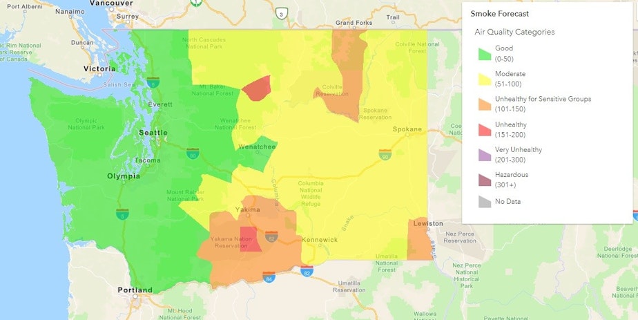
The new map gives real-time updates on air quality across the state, showing pollutants like smoke, ozone, and carbon monoxide . The map has accessibility features aimed at making it more user-friendly for those who are visually impaired, and can be accessed via smartphone or desktop.
RELATED: The presence of wildfire smoke could have you feeling bad — and not for the reason you think
Planning to enjoy some fresh air outdoors? The map also includes a smoke forecast to help people prepare ahead of time. It projects what air quality will be like over the next five days, said Department of Ecology monitoring coordinator Jill Schulte. The map also shows 7-day and 24-hour air quality trends.

While wildfire smoke typically peaks in August and September, it can start in July and linger into mid-October. The Department of Ecology says it plans to keep enhancing the map throughout the summer.
RELATED: Wildfire smoke is here to stay. But critics say our preparations are still 'lackadaisical'
Schulte also highlighted that the map comes has a web application that updates information every hour. Residents can visit the department’s website to explore the new map and download it to mobile devices.
-
Diana Opong

Diana Opong was formerly a general assignment reporter at KUOW.
More stories from Diana Opong »